Reinventing the General Plan
A Project of the California Planning Roundtable
With support from the American Planning Association, California Chapter
Great Model: City of Sacramento
Featured Principles: Create a Vision, Steward and Enhance the Environment, Look Beyond Local Boundaries
- Context
- Strong Regional Connections
- Sustainable Planning
- Communicating Areas of Growth
- Making Great Places
- Challenges and Lessons
- Background Information
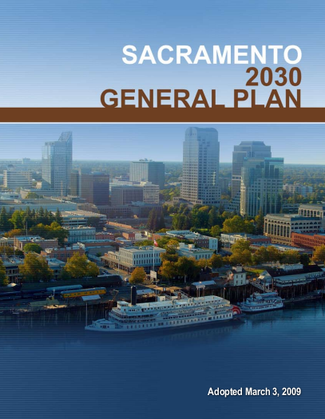
California's planning challenges and demands are becoming increasingly regional, including problems of growth management, climate change, and transportation. Many communities have struggled to integrate these issues into local planning, but the City of Sacramento General Plan demonstrates the transformative potential of a regionally-focused General Plan. Begun in 2004 and adopted in March 2009, the Plan recognizes changing patterns of growth, community values, and statewide and regional governance that have occurred since the last update in 1988. These include regional initiatives for smart growth (the Sacramento Area Council of Governments Regional Blueprint, adopted in 2004), state climate change legislation, and local initiatives for smart growth, infill, and transit-oriented development. Among its exemplary features:
-
Implementing regional smart growth strategies, and addressing other regional challenges
-
Establishing community livability and sustainability as overarching themes that serve as the framework for all plan goals and policies
-
Innovative illustrations, including a unique map that depicts the City’s intentions for distribution of growth and development that helped focus discussion on areas of change
-
Helping guide the creation of great places by describing their characteristics in place based categories based on the character and form of places, rather than traditional zoning categories
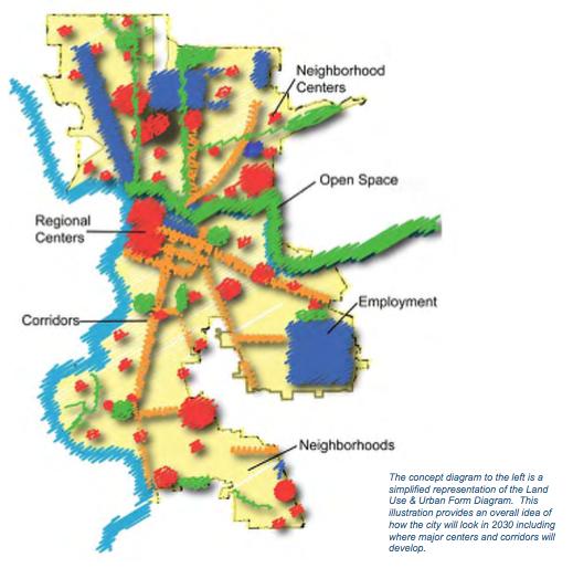
The Sacramento 2030 General Plan is a model for local municipalities in implementing principles for smart growth and sustainable development adopted by metropolitan planning agencies in “blueprint” plans. The Plan also serves as a model for the development of local plans that are consistent with regional transportation plans and sustainable community strategies required by SB 375.
The Sacramento General Plan builds upon regional growth strategies adopted by the Sacramento Association of Governments (SACOG) Regional Blueprint by allocating approximately two-thirds of its projected population and employment growth as infill of existing urbanized areas. Growth is allocated to the City’s downtown, in high-density mixed-use centers, at transit stations and along corridors, and as re-use of underutilized and obsolete commercial and industrial districts. Only when the capacities of the infill sites are approached will new development on the City’s periphery be considered.
The land use plan is correlated with a comprehensive mobility plan specifying transit, pedestrian, and as the last priority, roadway improvements that support its increased densities and mix of uses, while reducing pollution, greenhouse gas emissions, and other impacts. Policies are also defined to fund and upgrade existing urban infrastructure and services to accommodate the plan’s higher densities, while prescribing sustainable approaches that reduce utility demand.
The Sacramento 2030 General Plan is a model of comprehensive sustainable community planning, addressing environment, economy, and equity. The Plan’s introduction describes sustainability and livability as overarching themes that serve as the framework for the goals and policies embedded throughout all of its elements. As the reduction of greenhouse gases is one of a number of objectives for a sustainable community, Sacramento’s approach for compliance with the legislative requirements of AB 32 and SB 375 are also addressed throughout the Plan’s elements.
The Land Use Element’s emphasis on mixed-use, transit-oriented, and infill development are intended to reduce vehicle trips and increase community walkability. This, in turn, reduces air pollution, GHG emissions, energy consumption, noise, and personal commute times and enhances livability, public health, and the economic vitality of business districts—all sustainability objectives. These objectives are further achieved through:
-
Land Use Element policies for green buildings and land development practices
-
Mobility Element policies prioritizing non-automobile transportation modes
-
Infrastructure Element policies for water and energy conservation and alternative sources, and
-
Natural Resource Element policies for habitat and agricultural lands conservation.
Rather than addressing sustainability and climate change as separate elements, contributing goals and policies are embedded throughout the 2030 General Plan. Matrices are used to correlate climate change goals with specific applicable policies and implementation programs to enable the plan's users to understand the actions that will be undertaken by the City to reduce GHG emissions. The California Attorney General’s Office has endorsed this approach for communities in updating their General Plans as a means to satisfy AB 32.
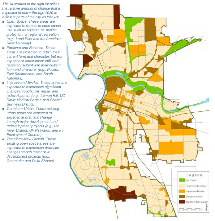
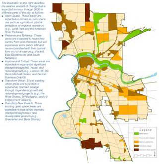
Typically, General Plan land use diagrams depict the intended “end-state” of development and, as such, fail to fully communicate which areas of the community will change, and which neighborhoods will see minimal modification.
The Sacramento 2030 General Plan incorporates an innovative diagram that effectively communicates the City’s intentions for areas in which change will be targeted and those that will be largely maintained with their existing uses and densities. This diagram is an important tool for General Plan update processes to help overcome residents' fears about the scale and form of change that are being proposed, minimizing controversy and better focusing the issues raised during the public hearing process. At the same time, it clarifies policies about the locations in which change will be considered, for staff, decision-makers, and developers.
Attaining public support for infill and higher density development is one of the most significant challenges facing planning programs addressing the issues of climate change and sustainability. Residents often oppose the scale and densities of development that have a meaningful impact on reducing vehicle trips, energy consumption, pollution, and GHG emissions. They cite concerns regarding impacts on local traffic, schools and parks, and community character.
The diagram changes the paradigm, differentiating the City into five proposed patterns for future change: (a) retained as open space; (b) retained for their existing use, form, and character; (c) significantly changed through infill, reuse, and redevelopment; (d) targeted for major development and redevelopment projects; and (e) transformed from open space to new development. More information about this issue is found in the Land Use and Urban Design Report, particularly pages 2-10 and 2-11.
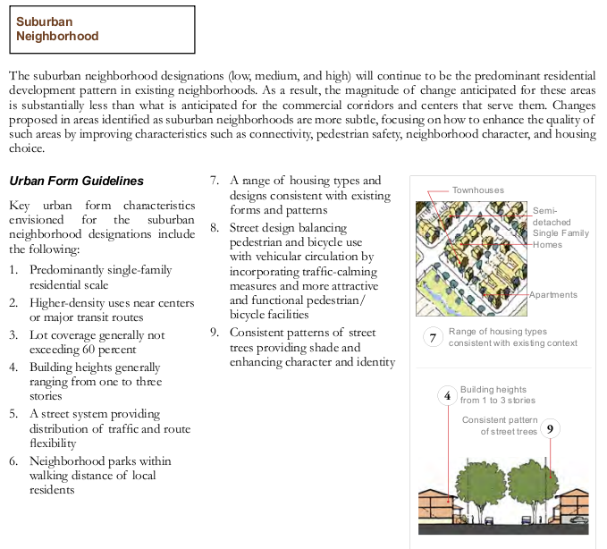
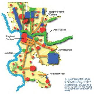
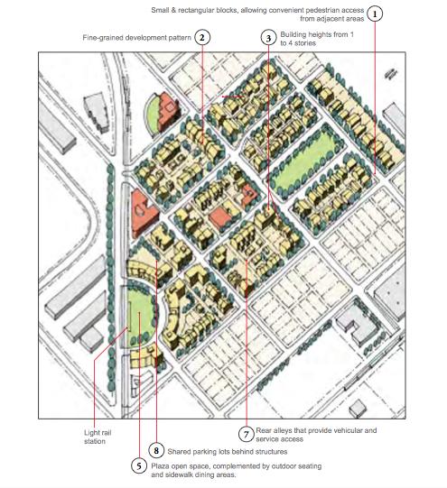
The Sacramento General Plan transcends the usual land use categories, such as “single family low,” “single family medium,” “commercial,” and “industrial,” by establishing categories based on the desired character of places, like “neighborhoods,” “centers,” “corridors,” and other special places. Each of these is intended to accommodate a mix of uses and may be differentiated by the location and massing of buildings in relationship to one another and the public realm and the inclusion of public amenities. For each category, the Plan prescribes the mix of permitted uses, minimum and maximum densities and floor area ratios, building heights, urban form and urban form guidelines.
More typical land use designations fail to give a clear sense of what development will look like, and can lead to public opposition, particularly based on fears about what higher density will look like. Typical multi-family housing categories, for example, do not discriminate between inward-oriented “stucco-boxes” from well-designed projects that contribute to neighborhood livability.
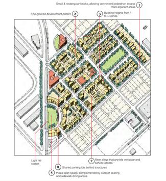
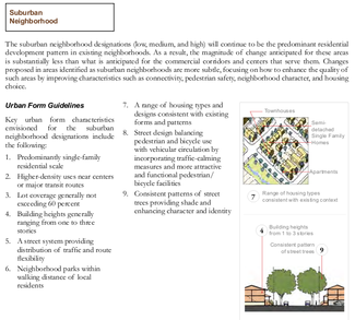
Instead, the City of Sacramento General Plan represents a hybrid approach that combines traditional zoning with guidelines for urban design, accompanied by diagrams and illustrations depicting the expected form and character of development.
More information can be found in the Land Use and Urban Design Report. Particularly see the following pages: 2-40 through 2-53; 2-66 through 2-77; 2-86 through 2-91; and 2-100 through 2-105.

KEY CHALLENGES
- Negotiation with the State Attorney General’s Office for AB 32 Compliance
The State Attorney General’s (AG) Office has aggressively pursued requiring communities to comply with AB 32 in updating their General Plans and preparing CEQA documentation. Mindful of this interest, City and consultant staff met with the AG Office early during the preparation of the 2030 General Plan. Among the issues discussed were the scope and specificity of plan policies, approaches for addressing these throughout the document rather than as a separate element (as had been suggested), methodologies for documenting greenhouse gas emission baselines and thresholds of significance, and timing of the preparation of the Climate Action Plan (CAP).
The AG’s expectations for these were significant and necessitated considerable negotiation to arrive at products that were mutually acceptable. Administrative draft goals and policies were reviewed for their completeness and specificity in addressing the AG’s recommendations. Among the issues raised by the AG’s Office were the absence of a quantifiable target for greenhouse gas emission reduction, requirements rather than incentives for green building practices, and preparation and approval of the CAP concurrent with the General Plan. In response, the City modified its administrative draft policies by adding GHG reduction targets and mandates for green buildings, while the AG’s Office concurred with postponing the CAP, provided that it would be completed within two years of the updated Plan’s adoption. - Public Acceptance of Development Infill and Intensification Acceptance of greater densities in the Sacramento 2030 General Plan benefited from the preceding work in developing the SACOG Regional Blueprint (See “Strong Regional Connections” tab), where residents, businesspeople, developers, and politicians established a consensus for increasing development densities within established communities, as a strategy for reducing environmental impacts and improving livability. While these principles were endorsed at the regional level, they became more problematic when applied at the neighborhood scale. Many individuals who generally support the concept of infill development in lieu of continued sprawl also objected to accepting densities in their neighborhoods or on adjoining blocks.
Four key techniques were used in the planning process to address these concerns. First, infill development was directed to areas of the community that had long been identified as blighted and in need of additional investment, and visual simulations were prepared to illustrate before and after conditions in areas targeted to accommodate change (see pages 58, 90, and 93 here). Secondly, development standards and guidelines were designed to assure clear transitions with adjoining existing uses, as well as to incorporate streetscape improvements, parklands, and other amenities that could only be achieved when linked to and leveraged by new development. This helped overcome public fears regarding degradation of development quality and the local environment. Thirdly, diagrams were prepared to distinguish areas in which new development would be accommodated and those that would be preserved (see “Communicating Areas of Growth,” above). Finally, discussion papers were prepared explicitly describing the trade-offs of infill in comparison with continued outward sprawl (e.g., increased local traffic with reductions in energy consumption, gasoline costs, and personal commute times).
LESSONS LEARNED
- Coordination with the Attorney General’s Office
In addressing climate change legislation, communities should take the initiative and be proactive in defining their agenda of policies and actions that contribute to the reduction of GHG emissions. Consult with the AG’s office early in the planning process to confirm its expectations and stress the commitment to develop a responsible plan, allowing for the modification of its specific recommendations to reflect the unique needs, characteristics, and political environment of the community. - Form-Based Land Use Designations
Developing new categories for the land use diagram could be a significant challenge for updating a general plan, but was not in the City of Sacramento, due to concurrence among Planning Department leadership for the approach integrating land use and urban form according to “place-based” categories. This can be frustrated by reluctance to change due to the familiarity of traditional categories by staff, developers, commissions and city councils, the community, and other users of the general plan. At a minimum, the transition to the application of a new land use mapping system requires education of its users, training of staff, and time. - Integration of Community Plans
Similar concerns may occur regarding the integration of community plans into the citywide general plan. Where community plans have been prepared and, particularly, where they are formatted as physically separate documents, they often function as the single policy guide and reference for development in that community. Merging the community plans into a comprehensive document necessitates changing established ways of business, involving education of its users, staff training, and time. - Using Visualization Tools for Public Education
Visualization of the implications of land use development policy options for physical form is a useful tool in attaining public support. Two-dimensional land use maps with tables listing permitted uses, densities, and building heights are insufficient to communicate how these options will appear. The use of illustrative graphics and visualizations effectively communicate a city’s intentions regarding the expected outcomes and quality of development.
WHAT WOULD HAVE BEEN DONE DIFFERENTLY?
The updated Plan’s goals, policies, and implementation programs are fundamentally sound and would benefit only from comparatively minor revisions. The Plan's most significant weakness was the inability to revise all of the City’s Community Plans concurrently with the General Plan update due to budget limitations. These Plans are improved through their restructuring and deletion of goals and policies that more appropriately belong in its citywide sections. However, there are a number of gaps within these, and they consequently fail to function as seamless and integrated policy documents.
Other issues that would be modified pertain to the planning process, rather than the content described above. The schedule for the preparation of the updated General Plan was extended due to a number of internal and external factors, including changing management personnel assigned to the work program. Largely, these changes were unavoidable, but their impacts might have been mitigated by greater coordination and communication between the lead consultant and City management team. Additionally, the City’s appointed General Plan Advisory Committee meetings would have benefited by developing an up-front agenda of meeting topics and processes, rather than their usual meeting-to-meeting scheduling.
Community Description
The City of Sacramento is located in the heart of California’s Central Valley at the confluence of the Sacramento and American Rivers. It is the cultural and economic center of its six-county metropolitan area and the largest city in the Central Valley. As headquarters of state government, Sacramento is widely recognized as the center of policy-making in the state. The greater Sacramento area has been cited as one of the five “most livable” regions in America, and the city has been touted as one of America’s most diverse cities.
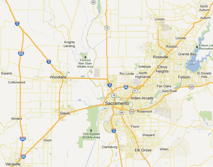
Sacramento is one of the fastest growing metropolitan regions in the country. The City’s population is projected to growth by increases of approximately 44% in population (450,000 to 650,000) and employment (334,000 to 474,000) by 2030. Historically, much of Sacramento’s growth occurred on the City’s edge, with residential subdivisions and business parks expanding into agricultural lands and greenfields. In recent years, the City endorsed several initiatives to re-prioritize the locations of new development as infill and in proximity to transit corridors and stations.
Timeframe of Plan Development
The planning process was initiated in August 2004 and the updated Plan was adopted on March 3, 2009, a period of approximately five years, four of which were used to develop the Plan and one year for public and agency review and adoption. The key steps included: (a) publication of a background report describing existing conditions and trends in June 2005; (b) confirmation of key planning issues by the City Council in November 2005; (c) adoption of the 2030 Vision Statement and Guiding Principles by the City Council in November 2005; and publication of the draft 2030 General Plan, Master Environmental Impact Report, and Fiscal Impact Analysis for public review and comment on May 8, 2008. The remaining 10 months involved public and agency review, negotiations with the California Attorney General’s Office, Planning Commission and City Council hearings, deliberations, and recommendations.
A description of the preparation process is available here (note pages 1-20 to 1-22).
Keeping on Track
The originally anticipated schedule for completion of the 2030 General Plan was extended approximately 10 months due to changes in City staff assigned to manage the project and efforts to fully engage all of the City departments and agencies that are affected by and/or have responsibility in carrying out the policies and programs defined by the Plan. The latter was an important step in transforming a critical policy document usually under the purview of a planning department into one that has relevance and ownership of all City departments.
Overall Vision of the Plan
The 2030 General Plan defines the vision that “Sacramento will be the most livable city in America.” This is elaborated by statements regarding the City’s role in the state and region, the vibrancy of its economy, its diversity and culture, character and livability of its neighborhoods and districts, relationships to and linkage with the region, importance of its historic and cultural resources, health and safety of its residents, and value as a model for sustainable development. Six themes implementing these visions are threaded throughout the Plan’s policies: making great places, growing smarter, maintaining a vibrant economy, creating a healthy city, living lightly-reducing our “carbon footprint,” and developing a sustainable future.
The Plan Introduction outlines this vision, especially on pages 1-2 to 1-7.
Community Reaction
Public testimony during the Planning Commission and City Council hearings on the draft 2030 General Plan and Master EIR were largely supportive. Most of the critical comments pertained to the inclusion of an area outside of the City’s boundaries in its planning area. A number of its residents, who were proponents of incorporation as a separate city, objected to potential annexation to Sacramento.
Public Participation and Stakeholder Involvement
Preparation of the updated General Plan involved an extensive process of public outreach and involvement. This included:
-
Meetings of a General Plan Advisory Committee composed of 25 individuals representing the City’s diverse constituencies serving in an advisory role to City staff and the City Council in developing updated Plan goals and policies, as well as liaisons with their constituencies. Thirty-five meetings were conducted during the planning program.
-
Two rounds of Town Hall Forums (a total of 26 events), providing opportunities for the general public to provide input in defining key issues, land use options, and preferred plans for the updated Plan. Each round of forums, which were presented at multiple locations throughout the city, involved highly interactive, hands-on exercises, enabling participants in small group settings to visually express their perception of issues and visions for the future.
-
High School and College Summits providing the opportunity for Sacramento’s youth and young adults to define their issues, visions, and input for land use alternatives for the future.
-
Four public open houses to present and receive feedback on preliminary General Plan draft goals and policies.
-
Destination 2030: Celebrating Sacramento’s Future was structured as a community convention in Sacramento’s downtown park to commemorate the release of the draft 2030 General Plan and FEIR and to provide an additional opportunity for public questions and comments prior to the adoption hearings.
-
General Plan Website, on which were posted information about the planning process, schedule of public involvement events, and working draft Plan documents.
In addition, presentations were made to neighborhood groups, business organizations, interest groups, developers, and other interested parties throughout the General Plan process.
Other City Departments' Involvement
Sacramento’s Planning Department engaged the diversity of City departments from the outset of the planning process to assure their understanding and ownership of the updated Plan. Responsible departments were assigned the task of developing and reviewing draft goals and policies for their sections of the plan. Meetings were conducted with department heads and division managers at key stages of the planning process to confirm pertinent issues, review existing policies and practices, comment on administrative draft updated goals and policies, and confirm final policy language.
A City Leadership Workshop provided the City's departments, appointed commissions, and elected decision makers with a unique opportunity for ownership of the updated Plan. Their representatives, as well as members of the City Council, participated in a four hour workshop presenting and soliciting feedback for key options addressing such topics as the City’s vision, land use development, and infrastructure financing. Choices for the future were presented visually by a video and in workbooks, followed by facilitated small group discussions where participants recorded their preferences on clip-out forms. The cumulative results from the groups were tabulated and presented in real time, enabling the participants to understand areas of consensus and difference. This workshop was critical in developing common understanding and support for the updated Plan by the multiplicity of its users and implementers.
Legal and Policy Context
The updated General Plan was prepared in compliance with the California Government Code Section 65300 et. seq., as well as recent legislation addressing climate change (Assembly Bill 32 and Senate Bill 375), complete streets (Assembly Bill 1358), and flooding (Assembly Bill 162). The Master Environmental Impact Report was prepared in accordance with the California Environmental Quality Act (CEQA). Its overall organization and goals, policies, and implementation programs addressing climate change were developed to support compliance with AB 32 and SB 375, contingent upon the subsequent preparation and adoption of a Climate Action Plan.
Consideration of Regional Issues
The Sacramento 2030 General Plan was developed consistent with and as the local implementation policy of the SACOG Regional Blueprint (see Strong Regional Connections tab).
Implementation Features
The 2030 General Plan provides a comprehensive program of actions to implement its goals and policies in a systematic and consistent manner. It describes each action to be undertaken, references applicable policies, identifies responsible and supporting departments or agencies, and defines a time frame for implementation. Priority is placed on updating the zoning ordinance based on the new land use-urban form categories and map, preparation of the Climate Action Plan, rezoning of key opportunity areas for infill development, updating the Community Plans, revision of codes for sustainable building design and development practices, linkage of the Capital Improvements Program to the General Plan, provision of adequate infrastructure to promote infill development, and developing and reporting a “Livability Index” that measures the effectiveness of the General Plan’s implementation on the quality of life for residents and the environment and economy of Sacramento.
Connection to Jurisdictional Budget
The Plan specifies that the City of Sacramento’s Capital Improvement Program must be correlated with the updated goals, policies, land use-urban form diagram, and infrastructure plans. Priorities are placed on funding improvements in areas targeted for infill and intensified development, particularly those accommodating uses that will reduce vehicle trip generation and length.
Adaptability
The 2030 General Plan incorporates a tracking system and “Livability Index” to assess performance of the Plan and includes mechanisms for adjustment of its policies and diagrams. This includes changes in the type, mix, and distribution of uses to account for changing market conditions, as well as infrastructure investments. It is premature to judge its utility at this time, but tracking procedures defined by the Plan’s Implementation Program are intended to inform staff regarding its effectiveness and enable the Plan to be adjusted over time to reflect any concerns.
Ease of Use
The 2030 General Plan was structured and written to enhance its utility by staff, City commissions, the City Council, developers, and the general public. Its organization, wording of goals and policies, inclusion of graphics, and linkage of policies with implementation programs were designed in consideration of this objective.
Graphics and Presentation Quality
As discussed in the “Communicating Areas of Growth” tab, the 2030 General Plan incorporates extensive graphics to illustrate planning and design concepts, principles, and standards. These enhance the common understanding of the City’s intentions for the form and character of its neighborhoods, corridors, centers, and downtown district. The expression that “a picture is worth a thousand words” emphasizes the importance of supplementing policies with images to communicate their meaning to staff, the public, developers, and decision-makers. Concept diagrams, illustrations, and photographs accompany each of the Plan’s land use-urban form categories; and a complementary land use diagram depicts areas of the City to be conserved and those to be preserved. Additionally, the Plan incorporates visualizations depicting before and after conditions enabling users to understand the physical form and quality of permitted development. Finally, photographs and graphics are used throughout the updated Plan to provoke public interest.
Organization
The Sacramento 2030 General Plan is organized in four sections: (a) Introduction (vision, themes, approach to climate change, description of organization, profile of existing conditions, and descriptions of legislative authorities, how to use the Plan, and how it was prepared; (b) Citywide goals and policies; (c) Community and special study areas goals and policies; and (d) General Plan administration and implementation. Matrices correlating plan policies with greenhouse gas emission reduction goals and technical reports are provided in the Plan’s appendices. Each of the elements mandated by state law and permissive Urban Design, Historic and Cultural, and Economic Development elements are incorporated in the citywide goals and policies section. These are organized by common topic to avoid redundancy and include:
- Land Use and Urban Design
- Historic and Cultural Resources
- Economic Development
- Housing
- Mobility
- Utilities
- Education, Recreation, and Culture
- Public Health and Safety
- Environmental Resources
- Environmental Constraints
The elements are inter-related by their consistency with the defined vision and six themes described above (“Overall Vision of the Plan”).
Costs (Expected and Actual)
The preparation of the Sacramento 2030 General Plan was budgeted for approximately $3 million, plus an add-on of approximately $1 million to address expanded public outreach and involvement, additional traffic model runs, development of GHG emission baselines for the EIR, consultation and negotiation with the California Attorney General’s Office, and preparation of supplemental goals and policies to address climate change and AB 32. Staff costs are additional and have not been calculated, though approximately the equivalent of five full-time planning staff was assigned to manage and participate in the development of the Plan.
It is not possible to discern the portion of the total budget that was allocated to the uniquely distinguishing elements of the 2030 General Plan described herein (i.e., local implementation of climate change legislation, growth strategy diagram, and integrated land use and urban form categories).
Adoption Process
Two workshops and one public hearing were conducted by the City of Sacramento Planning Commission for public comment and deliberations on the draft 2030 General Plan and Master EIR. Recommendations for approval with modifications were forwarded to the City Council for consideration. The Council conducted one workshop and two hearings for comments and deliberations and approved the Plan on March 3, 2009. In consideration of experience on comparable general plan programs, no unusual barriers or obstacles emerged during the adoption process.
CEQA Review
A Master Environmental Impact Report (MEIR) was prepared for the 2030 General Plan in accordance with the substantive and procedural requirements of the California Environmental Quality Act (CEQA).
Legal Challenges
No legal challenges were filed following the adoption of the 2030 General Plan.
Planning Staff and Consultants
Consultant staff included the following:
- PBS&J: Urban Planning and Environmental Services
- Mintier Harnish: Urban Planning and Community Planning
- Economic and Planning Systems, Inc.: Market and Fiscal Economics and Economic Development Policy
- WRT/Solomon E.T.C.: Urban Design and Urban Form
- Fehr & Peers: Traffic Analyses and Mobility
- Nolte Associates, Inc: Infrastructure Planning
- Circle Point/MMC Communications: Public Outreach and Involvement
- Valley Vision: Public Outreach and Involvement
- Cox & Company: Public Outreach and Involvement
Key City of Sacramento staff included the following:
- Tom Pace, Principal Planner
- Bob Overstreet, Strategic Projects Executive
- Desmond Parrington, AICP, Infill Coordinator
- Jim McDonald, AICP, Senior Planner
- Erik deKok, Senior Planner
- Alan Porter, Senior Planner
Complete listing of participating City staff: www.sacgp.org/documents/02_TableofContentsandAcknowledgements.pdf
Accessing the Plan
The Sacramento 2030 General Plan can be accessed online at: www.sacgp.org/documents/
Name of CPR Preparer of this Model
Woodie Tescher
Principal Technical Professional/Planning + Urban Design
PBS&J
13201 Wilshire Boulevard, Suite 430
Los Angeles, CA 90025
T 310.268.8132, F 310.268.8175, E ectescher@pbsj.com
Name of Primary Point of Contact at this Jurisdiction
Tom Pace
Long Range Planning Manager
City of Sacramento
300 Richards Boulevard, 3rd Floor
Sacramento, CA 95811
T 808.6848, F 916.808.7185, E tpace@cityofsacramento.org
Date Reviewed by Jurisdiction
May 10, 2010
CPR Peer Reviewers
David Booher, Cathy Creswell, Linda Dalton, Al Zelinka
CPR Project Team
Elaine Costello, Project Manager; Co-Chairs Cathy Creswell and Janet Ruggiero; Craig Beebe, Project Assistant
The Catalog
Our catalog contains a number of General Plan "Great Model" examples. Browse the entire catalog
Browse by Principle
- Create a Vision
- Manage Change
- Make Life Better
- Build Community Identity
- Promote Social Equity and Economic Prosperity
- Steward and Enhance the Environment
- Engage the Whole Community
- Look Beyond Local Boundaries
- Prioritize Action
- Be Universally Attainable
Browse by tag:
awards city climate-change context county equity graphics growth-management health implementation infill mature-community organization participation preservation redevelopment region rural smart-growth suburban sustainability town urban urban-design web-strategies
